NIVA: a case study on the use of Design Thinking for the development of a geotag app

NIVA: a case study on the use of Design Thinking for the development of a geotag app
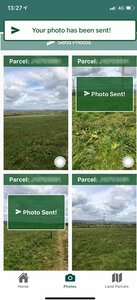
New IACS Vision In Action (NIVA) an H2020 project, aims to develop technologies that will deliver a seamless Common Agricultural Policy (CAP), through improvements to the key administrative platform – Integrated Administrative Control System (IACS). In Ireland, an interdisciplinary team led by the Department of Agriculture, Food and the Marine, with The Walton Institute (application development) and Teagasc (Socio-economic research supporting adoption) are developing a geo-tagged photo mobile application to support claim queries. In the event of supporting evidence being needed for a claim, farmers can use this application to take a geotagged photo of the land parcel in question and submit evidence directly to the paying agency. The application will reduce the need for inspections and accelerate claim processing.
A unique product development approach: Design Thinking
Application development uses multi-actor involvement to ensure the needs of all stakeholders are considered. This multi-actor approach has been guided by Design Thinking, an empathic guide to product development. A structured phase of understanding stakeholder needs precedes concept design. The Design Process has 5 phases and is not strictly linear, allowing iterative progression. The initial step [EMPATHISE] is concerned with understanding the perspectives of stakeholders. This leads to stage two [DEFINE] and allows for an informed definition of the key problems which in turn guide product design [IDEATE]. This collaborative approach leads to an early version of the solution [PROTOTYPE]. This prototype is further validated through rigorous lab and field testing [TEST].
Case study with the NIVA's geo-tagged photo mobile application
Each stage has structured activities to support knowledge acquisition. For example, the Empathise stage involved comprehensive stakeholder mapping. Next, key informant interviews helped develop a rich understanding of current experiences around technology usage in the sector. These insights helped to structure focus groups with 41 farmers from diverse profiles. The outcome of these sessions was a shared perspective on potential inhibitors and facilitators to app adoption. As a result, it was possible to reDefine the problem.
It became apparent that the focus on technology was too narrow and that any solution must consider other dimensions related to trust and value. Technical considerations such as reliability, usability and network access were highlighted as critical. From a trust perspective, some stakeholders felt the app might have negative consequences (e.g., they would be ‘caught out’). Regarding value, unless there were clear benefits for farmers (e.g., speed of processing) they would be unlikely to use it. Therefore, the solution is not just a technology but also must consider effective communication and supports like training.
 During Ideation, several workshops were held involving 73 participants in Ireland and other EU countries. These workshops helped elicit valuable ideas related to design, communication and adoption. Then, a first prototype was developed and tested with the continuous feedback cycle being reflected in the next iterations. The second prototype was tested with even larger groups of farmers, advisors and potential users in other EU countries.
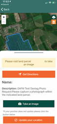
The responsive, user-centred approach to development is evidenced in the changes from prototype to prototype (currently version 3 is being tested) which reflect feedback from the comprehensive testing cycles. For example, several points of confusion were identified in earlier versions of the application. Consequently, a ‘get directions’ feature was added enabling farmers to easily navigate to the target land parcel. Additionally, new gallery layouts and status updates were added for the same reason.
Interest in the geotag app is high with requests from EU paying agencies outside of NIVA to test it. This work began in early 2019 and the latest version (v3) is currently being tested with over 100 target users and will inform the development of the final prototype due for release in Summer 2021.
 Christine O'Meara, Commercialisation Specialist at Walton Institute (formerly TSSG).


![]()